
Hindon River Front Development: Engineering the Restoration of a 25 km Floodplain Corridor
Reimagining the Hindon Floodplain through Integrated River Engineering
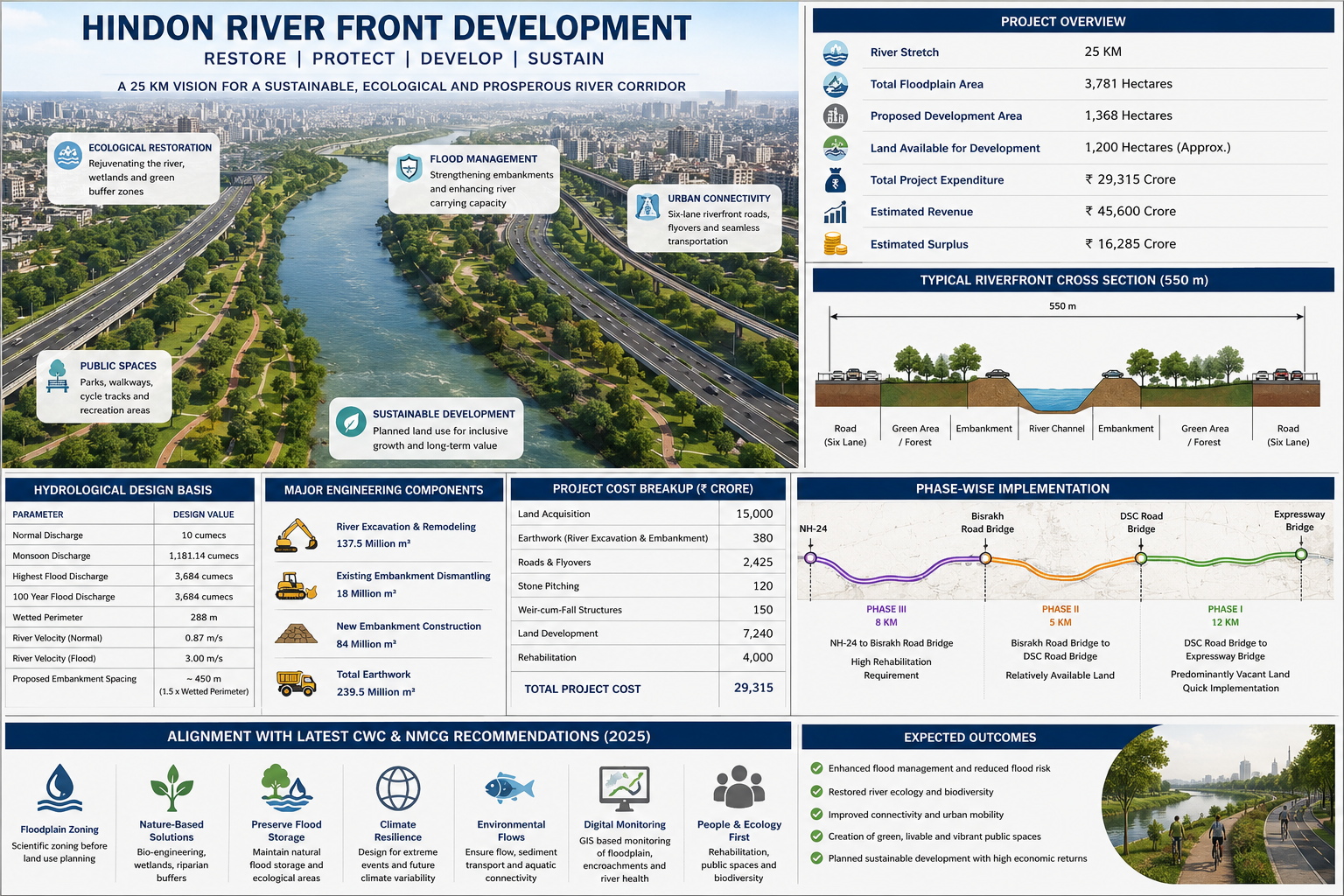
The Hindon River Front Development proposal presents a large-scale floodplain redevelopment framework for approximately 25 km of the Hindon River corridor. Unlike a conventional beautification project, the proposal integrates hydrological engineering, floodplain management, transportation infrastructure, land development, and environmental regulation into a phased implementation strategy. The report is organized into seven technical components: judicial directions, physical status assessment, planning proposals, land status, expenditure analysis, projected returns, and execution strategy.
Regulatory Framework
The project is founded on directives of the National Green Tribunal (NGT), which prohibit further construction within demarcated floodplains and require identification of existing structures for environmental scrutiny. The proposal also references Government Orders requiring prevention and removal of illegal encroachments, enforcement by district authorities, irrigation departments, and local bodies, and restrictions on public utilities for unauthorized developments within floodplain zones.
Hydrological Design Basis
The report adopts hydraulic design principles consistent with the Ganga Flood Control Commission (January 2004 Guidelines) and BIS IS 12094:2000 – Planning and Design of River Embankments. The design philosophy recommends that embankments protecting urban and industrial areas be designed considering 100-year return period floods, while accounting for the increase in high flood levels resulting from river confinement between embankments.
Hydraulic Parameters
The proposal documents the following engineering design parameters:
| Parameter | Design Value |
|---|---|
| Normal discharge | 10 cumecs |
| Monsoon discharge | 1,181.14 cumecs |
| Highest flood discharge | 3,684 cumecs |
| 100-year flood discharge | 3,684 cumecs |
| Wetted perimeter | 288 m |
| River velocity (normal) | 0.87 m/s |
| River velocity (flood) | 3.0 m/s |
| Proposed embankment spacing | Approximately 450 m |
The proposed embankment spacing is derived using 1.5 × wetted perimeter (288 m = 432 m) and rounded to 450 m for planning purposes.
River Corridor Cross-Section
The proposal introduces redesigned river cross-sections incorporating:
-
Primary river channel
-
Forest buffer
-
Riverfront green areas
-
New embankments
-
Six-lane roads on embankments
-
Integrated transportation corridor
-
Flood management infrastructure
Typical sections are illustrated for a 550 m corridor width, demonstrating coexistence of hydraulic conveyance, transportation infrastructure, and green spaces.
Floodplain Land Assessment
The report estimates:
-
Total Hindon floodplain area: 3,781 hectares
-
Proposed riverfront development area: 1,368 hectares
-
Remaining balance: 2,413 hectares
-
Potential developable land (55%): 1,327 hectares
-
Rehabilitation requirement: 127 hectares
-
Net land available for disposal/development: 1,200 hectares
The report further identifies approximately 810 hectares already under government ownership, comprising river land, Irrigation Department land, and Left Marginal Canal land, leaving 2,971 hectares proposed for acquisition.
Earthwork and River Training
The proposal includes extensive hydraulic modification works:
River Excavation and Remodeling
-
Excavation volume: 137.5 million cubic metres
Existing Embankment Dismantling
-
Earthwork: 18 million cubic metres
New Embankment Construction
-
Fill volume: 84 million cubic metres
Total Earthwork
-
239.5 million cubic metres
Using an estimated excavation rate of ₹158 per cubic metre, total earthwork expenditure is estimated at approximately ₹380 crore.
Transportation Infrastructure
The riverfront integrates significant transport infrastructure, including:
-
Two six-lane carriageways constructed over embankments
-
Approximate paved area: 1.25 million square metres
-
Estimated construction cost: ₹625 crore
-
Twelve proposed flyovers
-
Flyover cost estimate: ₹1,800 crore
Total transportation infrastructure expenditure is estimated at ₹2,425 crore.
River Protection Works
Additional hydraulic protection measures include:
-
Stone pitching over approximately 1.3 million square metres of embankment slopes
-
Estimated stone pitching cost: ₹120 crore
-
Construction of weir-cum-fall structures
-
Estimated cost: ₹150 crore
Financial Model
The report estimates:
| Component | Estimated Cost |
|---|---|
| Land acquisition | ₹15,000 crore |
| Earthwork | ₹380 crore |
| Roads & flyovers | ₹2,425 crore |
| Stone pitching | ₹120 crore |
| Weir-cum-fall structures | ₹150 crore |
| Land development | ₹7,240 crore |
| Rehabilitation | ₹4,000 crore |
| Total | ₹29,315 crore |
Using average land values derived from residential, group housing, industrial, and institutional land categories, the report estimates developed land value at approximately ₹38 crore per hectare, resulting in projected gross returns of ₹45,600 crore and an estimated surplus of ₹16,285 crore. These figures are the report's own projections and assumptions.
Phase-wise Execution Strategy
The proposal recommends implementation in three phases:
Phase I (DSC Road Bridge–Expressway Bridge, 12 km)
Focuses on predominantly vacant land, with an estimated completion period of approximately one and a half years. The report also links this phase to facilitating development of Sectors 139A and 139B under the approved Master Plan.
Phase II (Bisrakh Road Bridge–DSC Road, 5 km)
Relies on relatively available land with lower implementation complexity and a similar execution period.
Phase III (NH-24–Bisrakh Road Bridge, 8 km)
Identified as the most rehabilitation-intensive section prior to redevelopment.
Conclusion
The Hindon River Front Development report presents an integrated engineering proposal combining flood management, river training, embankment construction, transportation infrastructure, land redevelopment, and phased implementation. Its technical basis relies on hydraulic design criteria, flood frequency analysis, and financial projections while emphasizing compliance with judicial and governmental directions governing floodplain management. As presented in the report, realization of the project depends on coordinated land acquisition, rehabilitation, river engineering works, and adherence to environmental regulations throughout implementation.

{{item.comment}}
{{item.name}}
{{item.postDate}}